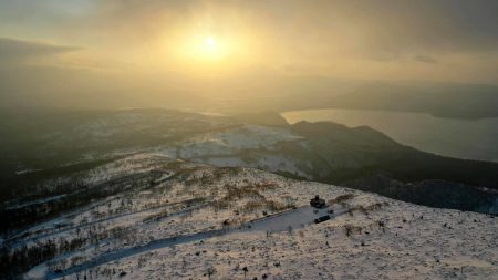

Location
Shiribeshi Area, Eastern Hokkaido
北海道中央部 後志地方
Date taken
12/2020
Altitude 1,225 m, 43° 16′ N, 140° 28′ E.
積丹岳、北に広がる日本海、南に見るニセコ連峰
積丹岳は北海道積丹町に位置する標高1,255mの山。山名はアイヌ語で「夏の村」の意味を持つ。山頂から北側に神威岬と日本海、南方にはニセコ連峰とその先の羊蹄山が望め、海と山、360度の景観が楽しめる。麓には山小屋が有り登山道もよく整備されているが、山体の南側斜面が大規模な地すべり地形になっているなど地形は急峻。このため地形が把握しにくい冬季は滑落・遭難事故も発生している。
Mt Shakotan, the Sea of Japan in the north and the Niseko mountain range in the south.
Mt Shakotan is a 1,255 m high mountain located in the town of Shakotan, Hokkaido. The mountain name means ‘summer village’ in the Ainu language. From the summit, you can see Cape Kamui and the Sea of Japan to the north, the Niseko mountain range to the south and Mount Yotei beyond, offering 360-degree views of the sea and mountains. There is a lodge at the foot of the mountain and well-maintained trails, but the terrain is steep, with a large landslide on the southern slope of the mountain. This makes it difficult to grasp the terrain, and in winter there have been slip and fall accidents.